
2014年6月7-8日香港海事博物館舉行“明代海洋貿易、航海術和水下考古研究新進展”
國際學術研討會
.jpg)
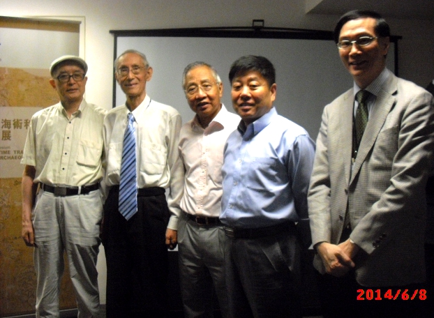
2014年6月8日全體講者在“世界海洋日”影於香港海事博物館門前的海畔(香港中環八號碼頭)
左起:Richard Wesley (韋持力)、周運中、謝必震、王式英、Robert Minte、 馮錦榮、
朱鑒秋、Robert Batchelor(貝瑞葆)、汪前進、崔勇、陳泳昌、劉義傑、Geoffrey Wade
(韋傑夫)、羊澤林、Roderich Ptak(普塔克)、錢江、 Stephen Davies(戴偉思)、陳佳榮、
臧振華、譚廣濂、焦天龍
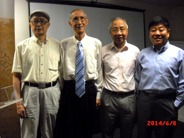
香港海外交通史學會學者於“世界海洋日”在香港海事博物館學術會上
[左起:陳佳榮、朱鑒秋、譚廣濂、錢江、馮錦榮]
[編者按]6月8日恰逢(經聯合國確定:自2009年起)每年一度的世界海洋日(World Ocean Day)。2009年“ 世界海洋日 ”的主題為“我們的海洋,我們的責任”。2012年“世界海洋日”的主題為“海洋與可持續發展”。2014年“世界海洋日”活動主題為“建設’海上絲路’,聯通五洲四海”。
“明代海洋貿易、航海術和水下考古研究新進展”
(New Research into the Maritime Trades, Seafaring and Underwater Archaeology of the Ming Dynasty)
日期: 2014年6月7-8日
地點: 香港海事博物館,中環8號碼頭
Date: 7th – 8th June 2014
Venue: Hong Kong Maritime Museum, Central, Pier 8, Hong Kong
會議程序
Symposium Program
第一天: 2014年6月7日 Day One: 7th June, 2014
8:45 - 9:15 註冊及簽到 Registration
9:15 - 9:30 Welcome Speech 致歡迎辭
Richard Wesley 韋持力(HKMM Director香港海事博物館總監)
Tianlong Jiao 焦天龍 (HKMM Chief Curator香港海事博物館總館長)
第一場:明代東西洋航海圖 Session one: The Selden Map
主持人:譚廣濂先生 Chair: Mr. K. L. Tam
9:30 - 9:55 錢江 James Chin 香港大學 University of Hong Kong
《明代東西洋航海圖》與福建人的海外貿易
The Selden Map and the Hokkien maritime trade in Late Ming
9:55 - 10:20 Robert Batchelor 貝瑞葆 Georgia Southern University 美國南佐治亞大學
Viewing the East Asian Archipelago Through the Selden Map
從《東西洋航海圖》觀察東亞群島
10:20 - 10:45 馮錦榮 Fung Kam-Rong 香港大學 University of Hong Kong
十六世紀末至十七世紀初東亞海圖繪製史的一些看法:以The Selden Map (或稱《東西洋航海圖》)與《中華帝國及其周邊王國及島嶼》(Sinarum Regni aliorūq. regnoru et insularū illi adiacentium descripti, 1590?-1593? ) 為中心
Issues in the history of cartography of East Asia from late 16th century to the early 17th Century: the Selden Map and Sinarum Regni aliorūq. regnoru et insularū illi adiacentium descripti
第二場:明代針經 Session two: Seafaring of the Ming Dynasty
主持人: 錢江教授 Chair: Professor James Chin
11:00 - 11:25 陳佳榮 Chen Jiarong 香港現代教育研究社 Modern Educational Research Society
明代的海路、海圖及針經
Ming Dynasty sea routes, navigation maps and rutters
10:25 - 11:50 謝必震 Xie Bizhen 福建師範大學 Fujian Normal University
《順風相送》與古代中琉航海
Shun Feng Xiang Song and the ancient navigations between China and Ryukyu
11:50 - 12:15 劉義傑 Liu Yijie 北京海洋出版社 Ocean Press, Beijing
《順風相送》研究八十年 A review of 80 years research on Shun Feng Xiang Song
12:15 - 12:40 汪前進 Wang Qianjin 中國科學院自然科學史研究所 The Institute of the History of Natural Sciences, Chinese Academy of Science
更路簿的理論探討—名稱、種類、源流、結構、特徵、價值與外傳
A theoretical discussion on the navigation guides (geng lu bo): names, variety, sources, structures, features, values and diffusion
第三場:明代沉船考古Session Three: Archaeology of Shipwrecks in the Ming Dynasty
主持人:謝必震教授 Chair: Professor Xie Bizhen
14:30 - 14:55 崔勇 Cui Yong 廣東省文物考古研究所水下考古中心 Center for Underwater Archaeology, Institute of Archaeology of Guangdong Province
南澳1號明代沉船及相關問題
Nan’ao No.1 shipwreck of the Ming Dynasty and relevant issues
14:55 - 15:20 羊澤林 Yang Zelin 福建博物院考古研究所 Institute of Archaeology, Fujian Museum
從福建明代沉船出水瓷器探討景德鎮瓷器外銷的幾個問題
Porcelains on the Fujian shipwrecks of the Ming Dynasty and the trading of the Jingdezhen porcelains
15:20 - 15:45 臧振华 Tsang Cheng-hwa 台灣中央研究院 Academia Sinica
台灣水下考古新發現與相關問題
New Discoveries in Taiwan underwater archaeology and relevant issues
15:45 - 16:05 焦天龍 Tianlong Jiao 香港海事博物館 Hong Kong Maritime Museum
南海地區沉船與明代海洋貿易的變遷
Shipwrecks in South China Sea and the changes of Ming Dynasty maritime trade
第四場:明代航海史 Session Four: Maritime History of the Ming Dynasty
主持人:臧振华教授 Chair: Professor Tsang Cheng-hwa
16:30 - 16:55 Roderich Ptak 葡萄鬼 Ludwig Maximilians University Munich
德國慕尼黑大學
Some Notes on Nan’ao in Portuguese Sources of the sixteenth century
十六世紀葡文資料記載中的南澳
16:55 - 17:20 Stephen Davies 戴偉思 University of Hong Kong 香港大學
On courses and course keeping in Ming Dynasty seafaring: probabilities and improbabilities
明代航海的航路和航向定位:可能性與不可能性
第二天: 2014年6月8日 Day One: 8th June, 2014
第一場:《東西洋航海圖》再探 Session one: Selden Map Revisited
主持人:貝瑞葆教授 Chair: Professor Robert Batchelor
9:30 - 9:55 譚廣濂 K. L. Tam 香港海事博物館 Hong Kong Maritime Museum
The Selden Map and some cartographic features of East Asia Maps in the late 16th/early 17th century
《東西洋航海圖》與十六世紀晚至十七世紀早期的東亞海圖繪製
9:55 - 10:20 朱鑒秋 Zhu Jianqiu 上海鄭和研究中心 Zhenghe Research Center, Shanghai
《東西洋航海圖》在南海史地研究中的價值
The value of Selden Map in the study of South China Sea historical geography
10:20 - 10:45 陳泳昌 Joseph Chen 香港獨立學者 Hong Kong Independent Scholar
由分野標記試論《東西洋航海圖》之成圖年代
On the composition time of the Selden Map based on a study on its Fenye
10:45 - 11:10 Robert Minte Boldeian Libraries, University of Oxford 牛津大學博德利圖書館
Conserving the Selden Map (TBD)
《東西洋航海圖》的修復和保護 (暫定)
第二場:明代中國與東南亞 Session Two: Ming China and Southeast Asia
主持人:馮錦榮教授 Chair: Professor Fung Kam-Rong
11:25 - 11:50 周運中 Zhou Yunzhong 廈門大學 Xiamen University
英藏明末閩商航海圖出自廈門新證
The author of the Selden Map was from Xiamen Bay
11:50 - 12:15 Geoffrey Wade 韋傑夫 Australian National University 澳大利亞國立大學
Southeast Asia in the Yale University Library Chinese Navigational Map Book
耶魯大學圖書館所藏中國航海圖中的東南亞
12:15 - 12:25 閉幕謝辭 王式英先生(香港海事博物館董事)
Conclusion Remarks by Mr. William Waung (HKMM Board of Directors)